[kl-bogel] Beginilah rupa bentuk mukabumi planet marikh.
Work "Mars Reconnaissance Orbiter" in the orbit of the planet (43 photos)
High-resolution camera (HiRISE) has received the first mapping images of the surface of Mars from an altitude of 280 km with a resolution of 25 cm / pixel! Take a look at these pictures.Layered sediments in the canyon Hebe. (NASA / JPL / University of Arizona)
Dents on the wall of the crater Gus. (NASA / JPL / University of Arizona)
")
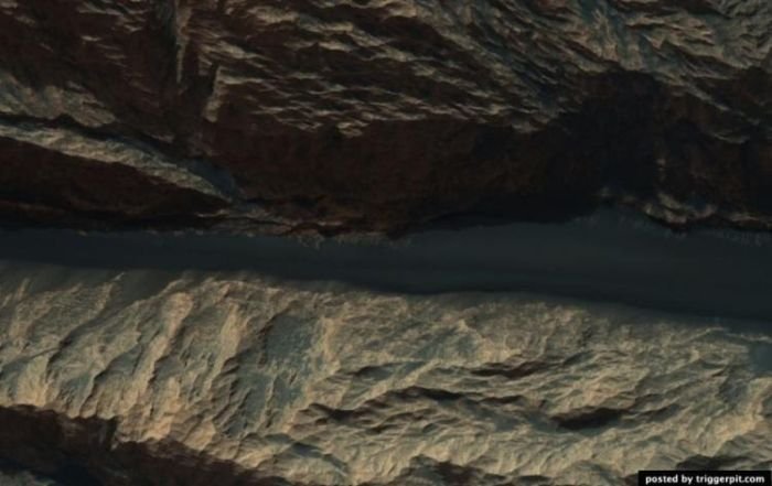
Russell Crater Dunes. (NASA / JPL / University of Arizona)
")
Geysers of Manhattan. (NASA / JPL / University of Arizona)
")
Martian surface covered with dry ice. Have you ever ever play with dry ice (of course in leather gloves!)? Then you have probably noticed that the dry ice from a solid to go directly to gas, unlike regular ice, which is heated, turns to water. Mars ice caps are composed of dry ice (carbon dioxide). When in the spring on the ice falling sun, it goes to a gaseous state, causing surface erosion. Erosion generates bizarre spider shape. In this photograph shows the channels that have arisen as a result of erosion and light-filled with ice, which comes in contrast with the muted red surrounding surface. In summer the ice is dissolved in the atmosphere, and instead will serve only as channels that are similar to ghost spiders, carved on the surface. This type of erosion is characteristic only of Mars is not possible under natural conditions on Earth as our planet's climate is too warm. Lyricist: Candy Hansen (March 21, 2011) (NASA / JPL / University of Arizona)
")
Layered mineral deposits on the southern tip located at the middle latitude crater. Bright layered deposits are visible in the center of the picture, they appear along the edges of mesas, situated on a hill. Such deposits can be found in many places on Mars, including craters and canyons near the equator. He could be formed as a result of sedimentary processes by wind and / Does water. Around the mesa visible dunes or folded education. Folded structure is the result of differential erosion: when some materials are amenable to erosion better than others. Perhaps, this area was once covered with soft sediments, which have now disappeared due to erosion. Text: Kelly Kolb (April 15, 2009) (NASA / JPL / University of Arizona)
")
Underlying rocks, the speakers on the walls and the central hill of the crater. (NASA / JPL / University of Arizona)
")
Solid structures in the salt mountain canyon Ganges. (NASA / JPL / University of Arizona)
")
Someone cut out a piece of the planet! (NASA / JPL / University of Arizona)
")
Sandy mounds, formed as a result of spring dust storms in the North Pole. (NASA / JPL / University of Arizona)
")
Crater with central mound with a diameter of 12 kilometers. (NASA / JPL / University of Arizona)
")
Cerberus Fossae fracture system on the Martian surface. (NASA / JPL / University of Arizona)
")
Proctor Crater Dunes purple. (NASA / JPL / University of Arizona)
")
Light rock outcrop on the walls of a mesa located in the Land of the Sirens. (NASA / JPL / University of Arizona)
")
Spring changes in the area of Ithaca. (NASA / JPL / University of Arizona)
")
Russell Crater Dunes. Photographs taken in the crater Russell studied repeatedly to track changes in the landscape. In this photo shows some dark entities that are likely to have arisen under the influence of multiple dust storms that have claimed the bright dust from the surface of the dunes. Narrow channels continue to emerge on steep surfaces of sand dunes. Deepening at the end of the channels can be the place where the accumulated blocks of dry ice before you go to a gaseous state. Text: Ken Herkenhoff (9 March 2011) (NASA / JPL / University of Arizona)
")
Troughs in the walls of the crater under the bare rock. (NASA / JPL / University of Arizona)
")
Troughs in the walls of the crater under the bare rock. (NASA / JPL / University of Arizona)
")
Territory, where possible contain a lot of olivine. (NASA / JPL / University of Arizona)
")
Gullies between dunes in Kaiser crater. (NASA / JPL / University of Arizona)
")
The Valley Mort. (NASA / JPL / University of Arizona)
")
Sediment on the bottom of the canyon maze at night. (NASA / JPL / University of Arizona)
")
Crater Holden. (NASA / JPL / University of Arizona)
")
Crater of St. Mary (Santa Maria Crater). The device did HiRISE color image of the crater of St. Mary which has the robokar Opportunity, which is stuck in southeastern edge of the crater. Robokar collecting data about this relatively new crater with a diameter of 90 meters, in order to determine what factors contributed to its emergence. Pay attention to the surrounding blocks and beams formations. Spectral analysis of CRISM detects the presence of hydrosulfates in the area. Debris robokara are at a distance of 6 kilometers from the edge of the crater Endeavour Crater, which are the basic materials and hydrosulphates filosilikaty. (NASA / JPL / University of Arizona)
")
Central peak of a large, well-preserved crater. (NASA / JPL / University of Arizona)
")
Russell Crater Dunes. (NASA / JPL / University of Arizona)
")
Layered deposits in the canyon Hebe. (NASA / JPL / University of Arizona)
")
District yardangov Eumenides Dorsum. (NASA / JPL / University of Arizona)
")
Movement of sand in the Gusev Crater, near the hills of Colombia. (NASA / JPL / University of Arizona)
")
North ridge of Hellas Planitia, which is probably rich in olivine. (NASA / JPL / University of Arizona)
")
Seasonal changes at the site of the South Pole, covered with cracks and potholes. (NASA / JPL / University of Arizona)
")
Remains of the southern polar caps in spring. (NASA / JPL / University of Arizona)
")
Frozen hollows and ruts on the pole. (NASA / JPL / University of Arizona)
")
Deposits (probably of volcanic origin) in the Labyrinth of the night. (NASA / JPL / University of Arizona)
")
Layered outcrops on the wall of the crater, located at the North Pole. (NASA / JPL / University of Arizona)
")
Single arachnid education. This formation represents the channels carved on the surface, which were formed under the influence of the evaporation of carbon dioxide. Channels arranged radially, widening and deepening as they approach the center. On Earth, these processes do not occur. (NASA / JPL / University of Arizona)
")
The relief of the Athabasca Valley. (NASA / JPL / University of Arizona)
")
Cones of craters Plain Utopia (Utopia Planitia). Plain Utopia (Utopia Planitia) - a giant plain, located in the eastern part of the northern hemisphere of Mars, and adjacent to the Great Northern Plain. Craters in the area of volcanic origin, as evidenced by their shape. Craters are almost not affected by erosion. Cone-shaped hills or craters, such entities shown in this picture, quite common in northern latitudes of Mars. (NASA / JPL / University of Arizona)
")
Polar sand dunes. (NASA / JPL / University of Arizona)
")
The interior of the crater Tooting. (NASA / JPL / University of Arizona)
")
Trees on Mars! In this picture we see something strikingly similar to trees growing among the Martian dunes. But these "trees" - an optical illusion. In fact, it's dark deposits on the lee side of dunes. They have appeared due to evaporation of carbon dioxide "dry ice". The evaporation process begins at the bottom of the ice formation, as a result of this process a couple of gas out through the pores on the surface and simultaneously tolerate dark deposits, which remain lie napoverhnosti. This picture was taken apparatus HiRISE, installed on board NASA Orbiter satellite reconnaissance in April 2008. (NASA / JPL / University of Arizona)
")
Victoria Crater. In the photo are visible deposits on the wall of the crater. Bottom of the crater is covered sand dunes. From left to see the wreckage robokara NASAOpportunity. The photograph was taken apparatus HiRISE, mounted on board the reconnaissance satellite NASA Orbiter, in July 2009. (NASA / JPL-Caltech / University of Arizona)
")
Linear dunes. These strips - linear sand dunes at the bottom of the crater in an area Noachis Terra. Dark areas - this is the dunes themselves, and light - the gaps between the dunes. Photo taken December 28, 2009 astronomical high resolution camera HiRISE (High-Resolution Imaging Science Experiment), installed aboard reconnaissance satellite NASA Orbiter. (NASA / JPL / University of Arizona)
")
via Source
--
You received this message because you are subscribed to the Google Groups "kl-bogel" group.
To post to this group, send email to kl-bogel@googlegroups.com
To subscribe or unsubscribe at http://groups.google.com.my/group/kl-bogel/subscribe
For more options, visit this group at http://groups.google.com/group/kl-bogel?hl=en
Sebarang email pertanyaan, hantar kepada abangmod@gmail.com
Comments
Post a Comment